Explained
Handheld GPS Units, Explained
After reading, you'll understand what multi-band, GNSS and expedition mode mean, how to compare battery claims, and which specs matter for your trips.
In this guide
Handheld GPS spec sheets are full of terms that sound alike. Multi-band and multi-GNSS are not the same thing, and a battery figure can mean very different conditions. First-time buyers often assume a bigger screen or a longer satellite list means a better unit. In practice, the combination of satellite hardware, battery type and screen decides how it feels on the trail.
The 30-second version
- Multi-band is separate from satellite systems, so check for it by name on the spec sheet.
- Compare GPS-mode battery life, because expedition mode records your position far less often.
- AA batteries let you carry spares, while rechargeable cells give longer rated life per charge.
- Water rating is nearly the same across these units, so it should not drive the decision.
- Phone pairing is optional, because all handhelds in this guide navigate on their own.
The products this guide is about
Our verdict on each, with the full reasoning on the companion review.
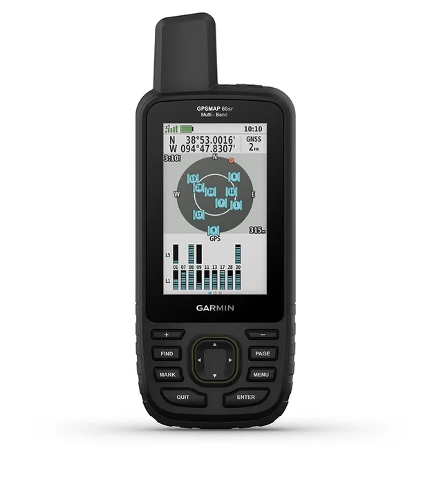
- Buy Garmin GPSMAP 66sr A multi-band handheld with a 3-inch screen and a rechargeable battery rated up to 36 hours.
- Buy Garmin GPSMAP 65 The same multi-band satellite tech as the 66sr in a cheaper, AA-powered body with a 2.6-inch screen.
- It depends Garmin Montana 700 A 5-inch touchscreen navigator that suits vehicles, groups and big-map planning more than a light pack.
- Skip Garmin eTrex 22x A small, light, 25-hour AA handheld that is easy to carry but is a generation behind on satellites and phone pairing.
What actually matters
- Multi-band support - It means the receiver uses more than one frequency from the satellites, which Garmin says improves accuracy where signals reflect or are weak. It matters most in canyons, valleys and forest.
- Satellite systems - GPS, GLONASS, Galileo and QZSS are different constellations, and tracking more of them can help in difficult places. A long list is useful but does not replace multi-band.
- Battery type - AA units let you carry spares and swap in the field. Rechargeable units often list longer life but need a charger or power bank.
- Rated battery life - Makers quote figures under set conditions, so real life varies with screen use, cold and tracking settings. Compare the GPS-mode number across models.
- Screen type - Transflective screens use ambient light and read well in sun. Larger touchscreens show more map but add weight.
- Preloaded maps - Some units ship with topo maps for a region, and others need maps added. Check whether the maps cover where you hike.
- Phone pairing - Bluetooth lets a unit send notifications and sync with an app. It is a convenience, not a requirement.
The specs, in plain English
Green flags vs red flags
Green flags
- Multi-band frequency support is listed by name on the maker's page.
- The spec sheet gives battery life with a clear mode, such as GPS mode.
- Preloaded maps cover the region where you hike.
- A microSD slot is listed for extra maps.
- The maker lists the water rating as a standard, such as IPX7.
Red flags
- Only GPS and GLONASS are listed for a unit you plan to use in canyons.
- The only wireless listed is ANT+ when you want phone pairing.
- A battery claim with no stated mode or conditions.
- Maps that cover a different region than your trips.
- A very small screen paired with a large map file.
Who's who: the brands
- Garmin - The dominant maker of handheld hiking GPS units, with models from compact AA units to large touchscreens.
- Magellan - A long-running handheld GPS brand whose current availability should be checked before you buy.
- Bushnell - Known mainly for optics and outdoor gear, so confirm any GPS product page before you buy.
- Suunto - Known for sports watches, dive products and compasses rather than handheld GPS units.
How to read a listing without getting fooled
Start with the satellite line and look for multi-band by name, then read the battery line and note whether it says GPS mode, tracking mode or expedition mode. Next check the battery type, since AA and rechargeable change how you plan trips. Then look at screen size and resolution, the list of preloaded maps and their region, and the wireless line for Bluetooth. Finally, check the water rating and weight, and confirm the product page is the exact model, since Garmin pages often show several related variants side by side.
How much should you spend?
Handheld GPS units fall into rough tiers. Budget units, such as the eTrex line, cover the basics with older satellite hardware and small screens. Mid-range units add multi-band support, sensors and phone pairing, and this is where most hikers should look. Premium units add larger screens, longer rated battery life or touchscreens, and they cost more mainly for comfort and size. Spend on multi-band support before screen size if you hike in rough terrain, and compare against a phone with offline maps before buying anything at the top tier.
Questions, answered
What is the difference between GPS and GNSS?
GPS is the U.S. satellite network, while GNSS is the general term for all such networks, including GLONASS, Galileo and QZSS. A handheld that tracks several of them is called multi-GNSS. Having more networks can help when part of the sky is blocked. It does not replace multi-band support, which is a separate feature.
Are expedition mode battery numbers realistic?
They come from a low-power tracking setting that trades track detail for battery life. Garmin lists a figure of up to 450 hours for the GPSMAP 66sr in expedition mode, compared with up to 36 hours in normal operation. The track you get is rougher, so it suits multi-day trips more than precise logging.
Do handheld GPS units need a subscription?
Garmin's pages for these four units list preloaded maps and do not mention a subscription for basic navigation. Extra map packs or services may cost extra. Check the maker's page for what is included before you buy.
Can a handheld GPS track a dog?
Some can. Garmin lists the Montana 700 as supporting dog tracking when paired to a compatible dog tracking system. That needs separate collar hardware. Our best dog GPS trackers comparison covers the collar side in detail.
Or jump to the head-to-head: Garmin GPSMAP 66sr vs Garmin GPSMAP 65.